Table of Contents
Fast Facts About the Branch
Surveyed Via Recta 1856, Warwick – Maryvale May 1909
Work started 7th December 1909
Opened 30th September 1911
Closed 1st November 1960
Status Via Recta Never fully Completed
Background
The Via Recta line was proposed to run a direct link from Brisbane to the Border allowing Queensland to maximize it’s potential for hauling goods traffic in competition to NSW.
Although construction of the line was approved and commenced, the final link between Maryvale and Mt Edwards was never completed.
The annual report of the Commissioner for Railways for the year 1884 which contained one very interesting remark of the Locomotive Engineer for the Southern and Western Line, concerning the direct line to Warwick.
“The trial survey from Spicer’s Peak Road Gap to Rosewood was completed early in June, the distance from the summit of the main range being about 44 miles. The decent of the range being 2,000 feet: the remaining portion of the line to Rosewood is over easy black soil country. An alternative route was tried over the summit of the main range at Swan Creek. As the survey would alter about four miles, run parallel to the trial survey from Spicer’s Peak, and not allow of Harrisville being reached without adopting a very heavy gradient, it was discontinued. A barometrical examination, which has been made of the country from Killarney to Coochin, via Wilson’s Peak and the head of the Condamine River does not show favourable results.”
A map included with the Report was hoped to have the effect of inducing the Government to push on the projected railway from Warwick to St. George without unnecessary delay, for it shows plainly the great effort of New South Wales is making to secure the trade of Queensland’s western and southern territory.
However, as these next news articles from the Warwick Argus will show, not everyone was in favour of the Via Recta Link
SATURDAY, JUNE 26, 1886 – With to-day’s issue of the Argus we present to our subscribers a sketch plan showing the route of the main Southern line of railway from Brisbane to Warwick, the extension to Stanthorpe, and the branch line from Warwick to Killarney. The plan also shows the route of the proposed lines – Rosevale to Warwick direct, and Warwick to St. Geo (WA) rge via Goondiwindi. Though not drawn to scale, it is fairly accurate, having been copied from the map issued by the Chief Engineer’s department last year. It will serve to keep prominently before the people of this district their rights as a community, and will also remind them of the fact that the dawn of the approaching session of Parliament – a session big with the fate of Warwick and the Southern darling Downs – is almost at hand. The £10,000,000 Loan Bill includes a sum of £500,000 for the direct line, and £250,000 for the line to St. George, and we have it on the authority of the present Premier – who is undoubtedly the first Constitutional authority in Australia – that, unless otherwise ordered by Parliament, loans must be expended on the purposes for which they were authorised. Our Toowoomba neighbours oppose both lines – a glance at the plan will show why. Toowoomba imagines itself a barrel; in reality it is only a bunghole, through which the trade of the Southern and Western districts finds its way to port. The provision of another and better trade faucet, as contemplated by the Government railway policy, would break the unjust monopoly Toowoomba has so long fattened upon at the expense of her neighbours. Hence the protests of the “patriotic” people of that town, who one and all seem to share Mr. James Taylor’s vision of a “reduction of ten per cent in rents” (in Toowoomba) as the certain outcome of direct rail communication between the metropolis and the border. It behoves the people of this district to push their claims without regard to the petty selfishness of their jealous neighbour; and we think they can be relied upon to pull together to secure the carrying out in its entirely of the railway system sketched in our supplement. Let them see to it that steps to that end are taken during the coming session.
SATURDAY, JUNE 26, 1886 – (WA) – The “VIA RECTA” – “The Town Talk” man of the Q-Times says:- That the Toowoomba people – or a section of them – are weeping and wailing again. That the trouble this time is the Ipswich to Warwick Railway that they think is monstrous that this line, which according to some of them is to cost millions – should be constructed at present. That, nevertheless, it will be constructed, despite the selfish and ungenerous opposition of the denizens of Redmudsky. That the via recta line will shorten the distance between Brisbane and Sydney, and that is a consideration which will outweigh any arguments against its construction that the Toowoomba people can adduce.
SATURDAY, JULY 3, 1886 – (WA) – THE “VIA RECTA.” – The Rosevale correspondent of the Queensland Times, writes under date 22nd inst., says: – Increased area are to be put under crop in the coming season, in anticipation of the first section of the via recta being nearly completed by the time the crop is fit for harvesting. The surveyors are now camped near the plain; and, although no information can be gleaned from them, still it is well known that the cost of construction of this section will be considerably below the average amount paid for other extensions. The country is all level, and no costly work will be necessary between here and where the section joins the main line. These nineteen miles of railway, I feel certain, will pay better than any other branch in the colony, for all along its course every inch is fit for the plough, and the quality of the soil cannot be excelled. I have learnt from your “Town Talk” man – long may be wield the pen in endeavouring to obtain their rights for the poor industrious toil worn cultivators of the soil – that the knights of Redmud City are determined to obstruct the making of this much needed railway, not only, it seems to me, because it will help us and settle a contented and thriving population on either bank of our stream, but because it will shorten the distance between the Downs and Brisbane by a number of miles, which must attract the attention of our legislators. Besides, what about the border trade, Stanthorpe, St. George, &c? Is that going around to Toowoomba to satisfy the cravings of a few interested individuals? Ah! No, don’t you believe it, Toowoomba! The people of Warwick and Stanthorpe and the farmers of Texas and on the border of New South Wales, are not going to pay extra freight to please any group of speculators who mean to monopolise everything that falls from Ministerial tables. The Toowoomba contingent ought to be content with the Highfields, Crow’s Nest, Beauaraba, and Drayton branches, without wishing to covet the traffic of other districts, at a serious loss and inconvenience to the residents, who are as worthy citizens, and as good colonists, as any other in that are in this country. Wake up Warwick and demand your just rights, and don’t stand by while other people trade on your good nature by endeavouring to make you believe that a one-horse railway will carry the produce of your products by extending to Grey’s range, into Brisbane via Toowoomba. Surely a Ministry who were retained purely and simply on liberal principles will never ignore the urgent wants of a class who are the bone and sinew of this fair colony. I mean the tillers of the soil, who win everything from the earth beneath their feet. Only a few have employment now where thousands will be comfortably housed and fed when this all important railway is finished.
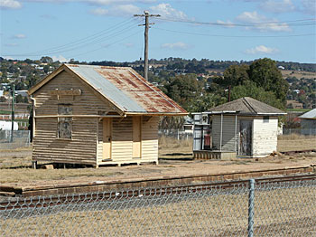
Warwick to Maryvale section (Maryvale Branch)
The line was surveyed from Warwick to Maryvale by Mr. Blackman in May 1909. Estimated cost to build the line was £63,424.14.1. Approval to build the line from Warwick to Maryvale was given on 7th December 1909. Mr. William Pagan was the Chief Engineer appointed to oversee the building of this line. Work began on 28th February 1910, and employed up to 164 men, 31 horse and dray teams, and 14 plough and scoop teams.
Premier William Kidston, officially started the work by turning the first sod on Friday 18th March, 1910. During 1910 & 1911, the building of the railway line was delayed on several occasions. Heavy rain during the winter of 1910 delayed the building the earthworks. Then between February and March, 1911 heavy rain caused flooding and washed away some of the earthworks already done.
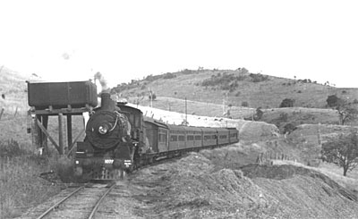
The line was officially opened by the Premier Mr. Denham on Saturday 30th September 1911. Two ladies held a royal blue ribbon 3” wide across the track while the locomotive passed through it.
SATURDAY, JANUARY 6, 1912 – (WA) – HEAVY STORM on MARYVALE LINE
Between 3 and 4 o’clock on Wednesday afternoon, a slight tornado accompanied by heavy rain of a short duration yield 2 inches. The downpour was responsible for some damage to the railway line near Clintonvale. Some of the corn and soil on one side of the rails were carried over to the other side and for a considerable distance the rails were completely hidden beneath the large deposit of earth.
Mr. Assistant Traffic Manager Ross lost no time in having the line open for traffic.
MONDAY, FEBRUARY 2, 1914 – THE MARYVALE LINE – Stranded at Gladfield
(Sunshine Express, December, 1989)
The southern part of the Darling Downs is particularly susceptible to storms and sudden downpours, whilst tornadoes and whirlwinds are not unknown. Damage to the permanent way and communications generally often occurs as a result of these storms.
Following three days torrential rain with intermittent hail the branch track between Warwick and Maryvale was in a bad state early in February 1914, these being frequent slips and washouts.
The train on Monday 2nd February 1914 had evidently run to schedule but the following day, the evening mixed to Maryvale was stranded at Gladfield because of washouts on the line. Gladfield in those days was not a bad place to get stuck; the Maryvale bound passengers and crew could console themselves in the cozy confines of the newly opened Gladfield Hotel adjoining the station while the rain fell outside.
Upon receipt of advice from the train crew at Gladfield, the District Superintendent at Warwick organized a ballast train and repair gang which was dispatched at daybreak from Warwick for the washout at Gladfield.
No attempt had been made by the train crew to continue to Maryvale during the night and the branch train commenced from Gladfield that Wednesday morning, evidently crossing the ballast train at Freestone, which was in those days a staff station with a station master in charge.
Despite a full days toil by the repair gang at the site of the washout, the evening mixed from Warwick has held up for 45 minutes on the outskirts of Gladfield, while the gang pigs tied the track.
Engineers report
REPORT OF THE CHIEF ENGINEER, SOUTHERN & CENTRAL DIVISION
Direct Line to Warwick.
30th September 1886
I have the honour to submit, for the information of the Hon. The Secretary for Public Works, the following report giving the result of my recent examination of the trial survey of the proposed direct line between Ipswich and Warwick.
I started from Warwick on Wednesday the 1st instant, and devoted nearly a fortnight to the inspection of the survey, and the various deviations suggested in connection with it, as well as in thoroughly examining the country along the eastern slopes of the Main Range between Spicer’s Peak and the heads of the Brewer, in order to determine the best and most economical route for the proposed railway. I was accompanied during my inspection by Mr. Surveyor C. B. Lethem, in whose charge the survey has been from its initiation to the present time, and received from him much valuable information and assistance in prosecuting the object I had in view.
DESCRIPTION OF ROUTE.
Having travelled from Warwick over the range towards Ipswich, I think it will be more convenient to adhere to the same course in describing the different features of the proposed line.
The survey commences at a point on the Main Southern line near the junction of the Killarney branch, 167 miles from Brisbane, at an elevation of 1490ft. above sea level. It then crosses the watershed between the Condamine River and Campbell’s Gully, traverses Campbell’s Plains and crosses Freestone Creek at 8 miles, where a station will be required to accommodate the settlement in the neighbourhood, as well as that in the valley of Freestone Creek. After crossing this creek the line curves round the north-westerly spurs from Mount Dumaresq, and approaches Glengallan Creek, which it follows up to Maryvale Station, 18 miles from Warwick. Provision will have to be made for stations on Glengallan Creek (11 miles), for the accommodation of the traffic from Glengallan head station, distance about four or five miles, at Gladfield (fourteen miles), and at Maryvale. About a mile beyond Maryvale the line crosses Pine Creek at an elevation of 1758ft., and a short distance further on the ascent of the western slopes of the Main Range may be said to commence. The line rises gradually with an average grade of about 1 in 87, running parallel will Millersvale Creek to the summit near the “road gap” on the northern side of Spicer’s Peak at a distance of 31_ miles from Warwick, the surface height being 2513ft. It is proposed to introduce a tunnel at this point, 12 chains long, the formation height of which would be 2365ft., or 148ft. below the surface. Thence the line has been surveyed on a falling contour of 1 in 66 the eastern slopes of the Main and Liverpool ranges, reaching the foot of the latter near the junction of the Bremer with Boyd’s Creek (366ft.) at a distance of twenty-five miles from the summit, or fifty-six and a-half miles from Warwick. The total height thus to be surmounted in ascending the range is 2000ft., of nearly 800ft. more than by the present line to Toowoomba. Leaving the Little Liverpool Range the line passes through Rosevale and down the valley of the Bremer, joining the main line of the Southern and Western Railway about two miles westward of Rosewood Station and thirty-seven miles from Brisbane. Several stations will probably be required between the foot of the range and Rosewood to accommodate the extensive farming settlement along the valley of the Bremer. The length of the line to construct between Warwick and Rosewood by the route just described would be seventy-three and a-half miles
ALTERNATIVE LINE, VIA JACK SMITH’S GULLY.
With a view to utilise a portion of the Killarney Branch Railway, an alternative survey has been made from Swan Creek Station, six and three-quarter miles from Warwick, by way of Jack Smith’s Gully, to Freestone Creek, where it joins the trial survey at eight and a-half miles. This route, although saving the construction of three and a-quarter miles of line, would increase the through distance by three and a half miles, and would avoid an important district not served by the Killarney Branch.
ALTERNATIVE LINE DOWN RANGE, VIA LONG TUNNEL AND MOUNT FRASER.
It is suggested that this line should leave the original survey at thirty miles from Warwick, turn to the left by one of the heads of Millersvale Creek, and cross the range in the vicinity of Mount Mitchell, where a tunnel would be required 85 chains in length; thence it would follow nearly the same route as the original survey, but at a lower level, to the watershed dividing Warrill Creek and the Bremer; keeping to this watershed it would pass through a low saddle in the Mount Fraser spur, cross the heads of the Bremer, and skirt the ridges between that stream and Boyd’s Creek until in joins the original survey at Rosevale. The feasibility of this line depends upon following a contour of 1 in 60 instead of 1 to 66. The latter was adopted in making the first survey in order to allow an ample margin for reduction in length due to curvature and the necessary easing of the grades on the sharper curves. I believe, however, judging by the experience gained on the surveys already effected, that it is practicable with the steeper contour to secure a ruling gradient of 1 in 50 with a reduction to 1 in 50 on curves of eight chains radius, and 1 in 66 on all curves under that.
The adoption of this line would probably result in somewhat less costly works if the long tunnel is excepted, on account of its being located lower down the slopes of the range, where the spurs are broader and the ravines less precipitous, whilst some nine miles of rough and difficult country along the Little Liverpool ranges would be altogether avoided. The distance by this route would probably be about two miles less than by the original survey.
LINE VIA MOUNT EDWARDS AND FASSIFERN.
This route has been proposed with the object of avoiding the eastern slopes of the main Range and reducing the ascent to a distance of from 10 to 12 miles. It is believed that this can be accomplished by adopting a ruling grade of 1 in 33, which would be reduced on the shaper curves to 1 in 40, so as to equalise the resistance in traction. Trial surveys are now in progress by this route, and from the reports of the surveyor, I have hopes of a favourable result.
Diverging from the trial survey near Spicer’s Peak (2365ft.), the line will follow generally the direction of that survey, but on the steeper contour for about three miles to a point below Mount Mitchell. Thence it will descend the watershed between Warrill and Reynold’s Creek, skirt the northern slopes of Mount Edwards, and, after crossing the last-named creek in the vicinity of Fassifern Station, join the second section of the Fassifern Branch now in course of construction at a point five miles from Harrisville and 47 miles from Brisbane. The elevation at the foot of the range on, this route being 730ft., the total height to be surmounted to formation level at the Spicer’s Peak tunnel is 1630ft. giving an average grade for the 12 miles of about 1 in 39.
The approximate length of line to construct by this route will be 61 miles.
Although opposed on the score of economical working to the general introduction of steeper gradients than in 1 in 50, I am of opinion that where an exceptional difficulty such as the ascent of the Main Range has to be overcome within a reasonable limit of cost, and use of an abnormal gradient is perfectly justifiable, provided it is confined to one particular section of the line where special auxiliary power can conveniently be applied in working the traffic, especially as, in this case, I believe the extra cost of working, if capitalised, would represent but a small proportion of the saving effected in cost of construction. This principle I have clearly admitted in dealing with the question of gradients in my report of the 28th January, 1879, on economical railway construction.
I propose to meet the difficulty of working this incline by providing specially powerful locomotive engines to assist trains in ascending. It has been suggested by the Locomotive Engineer, in order to secure the advantage of using heavier engines than can conveniently by placed on the 3ft. 6in. gauge, that a second line of rails should be laid outside the ordinary ones on a wider gauge. This, I consider, would answer admirably, and although it might not be necessary to resort to such an expedient at first, it would, I think, be well to keep it in view in designing the works, so that it could be adopted at a future time if the use of additional power desirable.
Besides the surveys to which I have drawn attention, barometrical observations were also made by the surveyor, with the view of ascertaining the practicability of crossing the range at the head of the Swan Creek, and a trial contour run for several miles on the eastern fall. The result of this investigation showed that the summit level, at this point, was considerably higher than at the Road Gap near Spicer’s Peak; a tunnel nearly half-a-mile in length would require; and the face of the range between Mount Huntly and Spicer’s Peak proved to be of such an unfavourable character that it was deemed advisable to abandon the route.
An examination was also made of the country in the vicinity of Wilson’s Peak with the object of taking the line up the valley of the Teviot Brook, and crossing the range on the head waters of the Condamine River, so as to connect with the Killarney Branch near its terminus. The ascent of the main range in this locality could probably be effected under more favourable conditions than at any other point under consideration, but the line would have to pass for some three or four miles through New South Wales territory, and some heavy work would be called for in following down the valley of the Condamine to Killarney. Although, in the event of a railway being constructed at some future time from Tenterfield in the direction of Wilson’s Peak, this route would prove a very direct one by which to connect Brisbane with the Southern colonies, it would in the meantime increase the distance via Warwick and Stanthorpe by some 25 miles, as compared with the line proposed via Spicer’s Peak and Millersvale; and in view of the contemplated construction of a line from Warwick to St. George, this extra distance would seriously affect the traffic between the Queensland Border and Brisbane.
THROUGH DISTANCES.
The through distance between Brisbane and Warwick by the principal routes above described is as follows : –
1st. Via Rosewood, Bremer, and Spicer’s Peak Road Gap 110 miles
2nd. Via Mount Fraser and Long Tunnel and Mount Mitchell 108 miles
3rd. Via Fassifern, Mount Edwards, and Spicer’s Peak Road Gap (1 in 33 gradient) 108 miles
As the distance from Brisbane by the existing line via Toowoomba to the point of junction of the trial survey near Warwick is 167 miles, the saving effected by the proposed direct line will be between 57 and 59 miles.
CURVES AND GRADIENT.
On the first section between Warwick and Pine Creek the curves and gradients are extremely easy, the minimum curve being 10 chains radius, and the steepest gradient 1 in 50; but, as the latter is only introduced in three places, the maximum length being a quarter of a mile, it is probable that a ruling gradient of 1 in 60 will be adopted for this section in making the permanent survey. From Pin Creek to the summit of the range the maximum gradient is 1 in 50, of which these is an aggregate length of 131 chains, but no continuos grade exceeding half-a-mile. The decent of the Main Range on the eastern side, as already explained, has been surveyed on a contour of 1 in 66 – the intention being to adopt a maximum gradient of 1 in 50, with such allowance as is necessary in order to equate the grades for curvature, and so obtain throughout a uniform resistance to traction. The minimum curve, which will necessarily be made use of to a large extent, will be 5 chains radius. On the last section from Rosevale to the junction near Rosewood, the line is laid out for a gradient of 1 in 66, and easy curves.
On the alternative line from Rosewood via Mount Frasier, it is anticipated that the curves and gradients will be very similar in character to those on the present survey
As already stated, the line projected via Mount Edwards and Fassifern is intended to be designed with a maximum grade of 1 in 33 over a section of about 12 miles. The curves will probably be easier than on the descent to Rosevale, the minimum being fixed at 7 chains. From the foot of the Range to Fassifern, the maximum grade will probably not exceed 1 in 66, and the minimum curve not be less than 10 chains radius.
CHARACTER OF WORKS AND PROBABLE COST.
The country traversed by the line between Warwick and Pine Creek (22 miles) presents no difficulties in the way of construction beyond that fact that no suitable timber, either for bridge timber or sleepers, is obtainable in the district, and it will, I believe, have to be procured at a considerable distance from the works. There is also a scarcity of material for ballast on the first 8 or 10 miles, but beyond this it can be obtained at convenient intervals. I estimate that the cost of this section (22 miles) will average about £4500 per mile.
Beyond Pine Creek the country changes considerably in character; it becomes more and more broken and rugged as the Main Range is approached, and the line crosses numerous deep gullies and creeks. This section (9 _ miles in length) extends to the summit of the Range, and will embrace some heavy earthworks, as well as costly provision for waterways, and cannot, I consider, be estimated under £10,000 per mile. A plentiful supply of ballast will be easily obtainable at various points, and timber of a suitable description for sleepers, fencing, or sawn stuff, is found on the slopes of the Range; but there is, unfortunately, and entire absence of any fit for bridge piles or girders, which will have to brought from elsewhere.
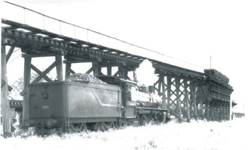
The 3rd section, in which is included the descent of the Main Range, extends from the Road gap at Spicer’s Peak to the banks of the Bremer near Rosevale. The line traverses extremely broken and difficult country, in some places skirting the almost precipitous sides of the mountains, in other piercing the more abrupt spurs and again crossing deep and rocky gorges in some instances exceeding 100ft. in depth. This will involve a continuous succession of important and costly works, deep cuttings and embankments, numerous tunnels, frequent bridges of large dimensions, and long culverts. The earthworks will probably average not less than 50,000 cubic yards per mile, whilst the iron bridges required to span the more formidable ravines will extend to an aggregate length of 3,780 ft. and cost £150,000; in fact, the works required in the construction of this part of the proposed railway will, I believe, be unsurpassed in magnitude by any as yet projected either in this or the neighbouring colonies. Those who have been accustomed to travel over the main Range by the present line between Murphy’s Creek and Toowoomba can form but little idea of the difficulties to be encountered in the construction of this line, the mountains being more precipitous and the range generally bolder and more stupendous in character. In many parts no little difficulty will be met with in the transport of men and material to the site of the works, and a large expenditure will consequently be inevitable to provide temporary roads of access.
I estimate that the line and works on this section will not cost less than £23,000 per mile, and may possibly exceed this amount, as it is extremely difficult, without detailed plans and quantities, to arrive at any close approximation to the cost of works of such magnitude.
The geological formation is basaltic throughout, and although excellent material for ballast is abundant very little stone fit for building purposes is available. Concrete therefore, would probably have to be resorted to largely in the composition of the works, but even this will be expensive on account of the scarcity of suitable sand for the purpose, which will, I anticipate, have to be procured from the country below the Range.
Timber, except for bridge piles, is fairly plentiful.
The 4th section, from Rosevale to the junction near Rosewood, passes over tolerably easy country, and is estimated to cost an average of £5,300 per mile. The junction with the Southern and Western Railway was originally located close proximity to Rosewood Station, but it was found desirable upon further investigation to remove it about two miles more to the westward, in order to cross the flooded ground in the vicinity of Western Creek at the narrowest and most favourable spot. A station in the locality will, moreover, prove a convenience to the neighboring settlement.
The works on the alternative line between the crossing of the range near Mount Mitchell and the watershed dividing the Warrill Creek and the Bremer would, a part from the proposed long tunnel, be very similar in character to those of the surveyed line, but on the lower portion, which avoids the rough country along the Little Liverpool Range, they would probably be lighter. In consequence, however, of the very large amount required in the construction of the tunnel (estimated at £112,000). I do not anticipate that the ultimate cost by this route would differ materially from that of the original line.
On the projected route via Mount Edwards and Fassifern, after leaving the original survey, the works necessary for the construction of the line would be of a much less costly description than by either of the lines along the Main Range. The earthworks would still be heavy, but few bridges would be required, and from the fact of the line following nearly down the watershed, the provision for waterways generally would be comparatively light. The first three miles on this section, running parallel with the original survey, I estimate will cost at the rate of £25,000 per mile; but thence to the foot of the spur the cost will probably reduce to £12,000 per mile. Between Fassifern and Harrisville the line will pass over undulating country possessing no special difficulties in the way of railway construction, and the cost may be put down approximately at £5500 per mile.
There is one consideration connected with this route which must not be lost sight of – namely, that its adoption will involve the reconstruction of the considerable portion of the first section of the Fassifern branch, as the grades on this, as well as the character of the works generally, are entirely unsuited to the requirements of a first-class main line. The cost of doing this is estimated at about £57,000.
COMPARATIVE TOTAL COST.
Leaving out account the difference in cost due to minor deviations, I estimate that the total comparative cost, based upon the respective mileage rates already quoted for lines by the two principal routes, will be approximately as under: –
1st. Line via Spicer’s Peak and Gap, to Rosewood £9555,875
2nd. Line via Mount Fraser and Fassifern, including reconstruction of first section, Fassifern line £529,625. Showing a saving in favour of a line by the latter route of £426,250; but seeing that the claims of the important settlement along the valley of the Bremer to railway communication cannot be overlooked, and that in any case a branch line will be required, it is only fair, for purposes of comparison, that the cost of this should be deducted from the saving effected by the adoption of the Mount Fraser and Fassifern line.
The cost of such a line may be put down at £81,075, which would leave the difference in the ultimate expenditure in favour of the Fassifern route at £345,175.
I may remark that these estimates provide for a first class permanent way laid with 60lb rails, squared sleepers, and a full complement of ballast. In regard, however, to the proposed incline on the Main Range Section of the Mount Fraser and Fassifern route I would advocate the adoption of a rail of even greater weight – say 75lb. per yard – on account of the heavy engines which will be required to work it, as well as the severe wear and tear due to the application of powerful brakes in descending.
PROBABLE TRAFFIC.
As bearing upon the question of the local traffic which is likely to arise in the district traversed by the proposed line, I would draw attention to the extensive settlement already existing on Campbell’s Plains, as well as that bordering on Freestone and Glengallan Creeks. The traffic from this is at present carried by road to and from Warwick, the distance across to Killarney Branch precluding its being served by that Line.
The country extending from Maryvale to the summit of the Range is at present only used for grazing purposes, but parts of it, especially on the western slopes of the Range, appear particularly well adapted to fruit growing and other agricultural pursuits, and will, at some future time, if brought within reach of railway communication, support a considerable population. In the vicinity of the line at the summit of the range, there are numerous situations admirably adapted for sites of future residences, and, considering the advantages of elevation (2500ft.) and the beauty of the surrounding scenery, there is every prospect, I believe, of this locality becoming hereafter a favourite summer resort and valuable sanatorium for the people of Ipswich and Brisbane.
Between the summit and the foot of the range by either route the line would not secure any local traffic, being in most places inaccessible, whilst the adjoining country is unfit for settlement of any description. On this account the line via Mount Edwards and Fassifern has a great advantage, as the unremunerative portion is limited to some twelve miles instead of twenty-five miles by the other route.
From the foot of the range near Mount Edwards to its junction with the Fassifern Branch the line would traverse land suitable for settlement, from which traffic would eventually be obtained.
As regards traffic on the other route between the foot of the range and Rosewood, I have already pointed out the importance of the settlement along the valley of the Bremer and its claims to railway communication.
Apart, however, from the question of local traffic, the importance of the direct line to Warwick, in connection with the future through traffic between Queensland and the Southern colonies, cannot be overestimated, seeing that its construction will effect a saving in the through distance of nearly sixty miles, as compared with the existing line via Toowoomba. But what I submit to be of equal if not greater moment is the fact that, combined with the contemplated line from Warwick to St. George, it would be the means of securing for this colony the traffic along the south-western border, which otherwise would in all probability be drawn towards New South Wales.
CONCLUSIONS.
After carefully weighing the merits of the various schemes proposed for the direct line both in respect of the engineering features, the probable cost and future working expenses, as well as anticipated traffic, I have no hesitation in advising that the route via Campbell’s Plains, Spicer’s Peak, Road Gap, and Fassifern should be adopted.
The reasons which have led me to this conclusion may be briefly summarised as follows: –
1st. The large saving in first cost of construction, amounting to £426,259, or if allowance is made for the construction of a branch line to Rosevale, a saving in the ultimate expenditure of £345,175.
2nd. That against this saving the extra cost of special locomotive engines to be employed on the Main Range section, together with the capitalised value of their working expenses, will not exceed £32,500.
3rd. The shorter length of unproductive line in respect to local traffic compared with the route to Rosewood.
4th. The shorter length of railway to construct, the lesser magnitude of the works involved, and the consequent greater rapidity with which the line could be completed.
A map is attached descriptive of the various lines referred to in this report.
I cannot close without acknowledging the able manner in which the various surveys connected with this important undertaking have been effected by Mr. Surveyor Lethem. He has had a task of no ordinary difficulty to perform, and to the energy and perseverance displayed by him is, I consider, chiefly duo the successful issue of the field operations.
Stations built on the line
Below is a list of stations along the section of line that was built.
|
m
|
c
|
Height above
sea level
|
Station
|
| (from Warwick) |
|
|
|
| 0 |
0 |
1485 |
Warwick |
| 0 |
47 |
– |
Killarney Junction |
| 2 |
16 |
1565 |
Womina |
| 4 |
9 |
1585 |
Sladevale |
| 6 |
53 |
1630 |
Campbell’s Plains |
| 8 |
76 |
1694 |
Freestone |
| 11 |
57 |
1632 |
Clintonvale |
| 15 |
46 |
1661 |
Gladfield |
| 19 |
1 |
1688 |
Maryvale |
|
|
|
|
| (from Ipswich) |
|
|
|
| 39 |
70 |
616 |
Mount Edwards |
| 36 |
2 |
352 |
Aratula |
| 34 |
30 |
307 |
Morwincha Watering Station |
| 32 |
60 |
290 |
Fassifern Valley |
| 31 |
34 |
303 |
Warumkarie |
| 29 |
39 |
257 |
Kalbar |
| 26 |
56 |
243 |
Waraperta |
| 23 |
64 |
274 |
Munbilla |
| 22 |
9 |
190 |
Radford |
| 20 |
54 |
184 |
Wilson’s Plains |
| 18 |
50 |
175 |
Harrisville |
| 15 |
77 |
157 |
Churchbank |
| 13 |
72 |
240 |
Flinders |
| 12 |
73 |
162 |
Peak Crossing |
| 11 |
68 |
151 |
Rockton |
| 10 |
67 |
150 |
Hillside |
| 9 |
73 |
133 |
Goolman |
| 8 |
7 |
159 |
Purga |
| 6 |
71 |
109 |
Hampstead |
| 5 |
21 |
150 |
Loamside |
| 2 |
14 |
84 |
Churchill |
| 1 |
73 |
|
Cattle Siding |
| 1 |
29 |
|
Noble vale No.6 Col. Sdg. |
| 1 |
24 |
93 |
Little Ipswich |
| 1 |
7 |
|
Spann’s Siding |
| 1 |
1 |
— |
Shillito and Son’s Siding |
| 0 |
0 |
57 |
Ipswich |
Closure of the line
PUBLIC NOTICE
The following sections of railway will be closed for public traffic on and from 1st November, 1960:
– Beyond Munbilla to Mount Edwards; and the Maryvale Branch.